The Malaspina Art Society: Summer 2020 MAS Group Show: Intertidal Impressions. Exploring the space between land & sea through various media. This blog mentioned. Thanks!

Opening JUNE 4 – SEPTEMBER 15, 2020 Intertidal Impressions: Exploring the space between land & sea through various media.

The Malaspina Art Society’s Summer Group Show features qathet region artists exploring the changing sights, sounds, smells, motion, textures, plants and creatures of our northwest intertidal zones: the area of the marine shoreline that is exposed to air at low tide, and covered with seawater when the tide is high; its dynamic nature serving as a metaphor for resilience and adaptation.

See call for artists and more details here

Our Tide Related Artworks page is used as a reference and source of possible inspiration, as in:

“Site with inspirational mixed media works on tidal zones  https://tidalcultures.wordpress.com/tidal-art-works/”


“Dutch Fair”, a kind of tidal market, held at Great Yarmouth, and maybe elsewhere too, added to our (Poetic) Tidal Glossary. “Dutch pipes, dried flounders, wooden shoes, apples, and gingerbread, are then offered for sale.”

We have added this to the Tidal Glossary 

But it is so interesting we are posting it here too.

Dutch Fair. A fair, or market, on Great Yarmouth Beach, but we think other places too, where Dutch barges would beach at high tide, sell goods to local shoppers, then set sail again at the next high tide. There is quite a famous painting by George Vincent which can be seen here.  From Hugh Aldersey-Williams; Tide: The Science and Law of the Greatest Force on Earth.  Another online account describes the scence;

“The “Dutch Fair”, as it is denominated, is held on the beach, and presents an interesting appearance. From twenty to thirty of their falt bottomed boats are run on the shore at high water, and as the tide receded, are left high and dry.  Dutch pipes, dried flounders, wooden shoes, apples, and gingerbread, are then offered for sale, and if the weather be fine, the beach is throunged with company, many of whom come from a great distance.”

Great map of the Severn Estuary from 1595.

This is online at the British Library here

The online notes are as follows.

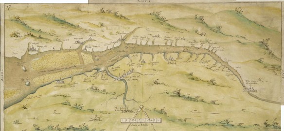
“This is a chart showing the Bristol Channel and the River Severn. Sandbanks in the River Severn are indicated by stippling and the draughtsman has indicated the ‘Channell betweene the groundes’. The tributries of the Severn are indicated and figures along the banks record the distance in miles between their mouths. Locations of note, such as Bristol, Bath and Newport are represented by generalised perspective views of houses and churches. The map is thought to date from 1595, reflecting the fear that the Spanish were planning to invade the Bristol Channel in the 1590’s, rather than initiate a more obvious and direct attack via the English Channel. The Anglo- Spanish relationship had steadily deteriorated since the accession of the Protestant Elizabeth I. Raids on transatlantic shipping by English seamen such as Francis Drake and England’s support of the Protestant rebellion in the Spanish ruled Netherlands had brought tensions with Spain to a crescendo culminating in the events of the Spanish Armada. Although the Spanish Armada was defeated by the English in 1588, England remained at war with Spain for many years and further attempts to invade were made by Philip II. In 1595, the year this chart was produced, the Spanish attacked Mounts Bay, Newlyn and Penzance.”

Strikingly, the huge oxbow bend in the river below Gloucester is not  really shown at all. Also all the pills, or smaller tributaries, are shown and named as they would have been much more important, in various ways, in those days.

To see it in detail got to the link above and to the zoom function

sevenr estuary map