
Drawn from traditional, local, historical, topographical, literary, scientific and vernacular sources.
This Tidal Glossary began on January 23rd 2015. The Tidal Cultures blog it is embedded in emerged from a creative research exchange project I ran between 2012 and 2014, which curated a series of exchange visits between artists and scholars with interests in the Severn Estuary, and counterparts with interests in the Dutch Wadden Sea. My co-applicant and co-leader on the project was professor Bettina van Hoven of Groningen University.
Both these places, although markedly differing landscapes in many ways, are united by sharing extreme tidal rhythms. The Severn Estuary has a huge tidal range and areas of inter-tidal land. Whilst the tidal range in the Wadden Sea is not so extreme, it has even larger areas of intertidal space due to the local topography. Both places share sea walls, saltmarsh margins, lots of mud, and all the local culture and ecology that is shaped by the tides.
I have been fascinated by tides, and particularly the huge tides of the Severn Estuary and Bristol Channel, since I was a child, as I grew on a farm which bordered the estuary in one very striking place, and also had fields on the Wentlooge Levels, ‘the moors’, as we called them, between Cardiff and Newport. I subsequently lived in other places on, or near the estuary shore, always watching, or sensing the tides which rose and fell in enthralling daily, monthly and seasonal rhythms. Counterposing this fascination with, and love of, tidal places was a growing awareness of the impacts of modern society on nature in general and estuary landscapes in particular.
The Severn Estuary has long been under threat from all manner of pressures and developments, including vast barrage and tidal lagoon schemes. Many other UK estuaries have been degraded, even erased, or face uncertain futures. So the Tidal Cultures blog, and other writings and ventures, were, in part, to raise awareness of these amazing and important landscapes and to express my care about, and love of them.
As I photographed and wrote about tides, estuaries and the Severn Estuary, first for an arts degree in Bristol (a famous tidal city), and then in my meandering ‘career’ as a cultural geographer with interests in nature, the environment, place and memory, I collected many books and other references, on the Severn Estuary, other estuaries, and about tides more widely. It became clear that tides have such a rich culture of words and terms in local traditions, folklore and literature, that it seemed a collection of these would be of interest, so the tidal glossary began.
I have focused on more ‘poetic’ terms; particularly local, vernacular, obscure and/or historic terms. These range from many words about the differing states and stages of the tides, to terms linked to time and the moon, to tidal currents, sailing, fishing and coastal feature terms. Scientific books on tides, of which there are many, have many technical terms in them, but these are mostly not included. Many of the entries below are short quotes from other sources. Most are credited. A few might be lost.
There are around 213 terms in the Glossary (as of 15 01 2026).
Special thanks are due to Heather Green for many inspirations (see HG). Thanks also to others, including Rhyddian Jones (RJ), for some suggestions. More are very welcome. Please email me, owain.oj.jones(AT)gmail.com
A very few terms are newly coined, from a project being conducted by Heather Green with support from me, Owain.
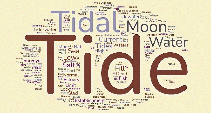
Here is a word cloud of the terms in the list.
Aestus. “The term estuary is derived from the Latin word “aestus” meaning tide and refers to a tongue of the sea reaching inland”. This is the opening line from the book; Estuaries: Monitoring and Modelling the Physical System, by Jack Hardisty, 2007. Pdf here.
Age of the Moon. Where the moon is in its monthly cycle from new to full. Source: H. Derek Howse; Some Early Tidal diagrams; 1985; Lisboa: Instituto de Investigação Científica Tropical. This term also relates to the lag in time between a full moon showing and the high tide it brings. This can vary by days in differing locations. This is because of coastal and oceanic circumstances slowing down the rise of the tide. This is well explained in Johnathan White’s Tides. The Science and Spirit of the Ocean.
Age of the Tide. “An old term for the lag between the time of a new or full moon (SYZYGY) and the time of maximum spring tidal range.” This was found in a Tidal Glossary on line which now seems to have gone. Author unknown, but it said: “adapted from the Glossary in Changing Sea Levels: Effects of Tides, Weather and Climate by David Pugh, Cambridge University Press, 2004 with permission of the author and publisher”. The age of the tide is well explained in Jonathan White’s Tides. The Science and Spirit of the Ocean. (2017). He explains that the term relates to the lag in time between a full moon showing and the high tide it brings. This can vary by days in differing locations. This is because of local coastal and oceanic circumstances slowing down the rise of the tide.
Anchialine Pools. These are land-locked, mostly small bodies of water of varying salinity that are adjacent to the ocean. These pools have indirect, underground connections to the sea and thus show tidal fluctuations in their water level. They only occur in very specific coastal locations where underground channels to the sea run through rock strata such as lava formations or young limestone. They often have very rare biotic communities. See here for Hawaiian examples.
Apflod. Anglo-Saxon word for low tide. From Hugh Aldersey-Williams; Tide: The Science and Law of the Greatest Force on Earth. 2016.
Aphelion. The earth’s orbital point farthest from the sun when the sun is the centre of attraction, as opposed to perihelion. This is one of the many obscure factors affecting cyclical variation in tide height and range. (Source; http://www.waterlevels.gc.ca/eng/info/glossary).
Apogean Tides. Tides of decreased range or currents of decreased speed occurring monthly when the moon is near apogee. (Apogee. That orbital point farthest from the Earth when the Earth is the centre of attraction, as opposed to the Perigee). (Source; http://www.waterlevels.gc.ca/eng/info/glossary).
Back and Fill. A sailing term; “To use the advantage of the tide being with you when the wind is not.”
Basket-Weir. A kind of fish trip that could be set and cleared at low tide. A basket-weir was a structure of post and rails set permanently in the intertidal area to which fish traps were attached in ranks. See Hedge Wier; Fish Trap; Putcher; Putcheon; Putt; Kype.
Bawley. An “English sailing vessel typified by a boomless cutter rig and probably named for having a boiler for cooking shrimp in amidships. “The majority were built by Aldous of Brightlingsea”,[1] but they were also built in Harwich, Erith, Southend, Leigh, and on the Medway.” All that quote is from Wikipedia. Bawleys are discussed as a Thames estuary craft in Rachel Lichtenstein’s 2016 book Estuary.
Besid-Neap. [Sea Term] a term for low Tide. Found in an English dialect dictionary here. No other info to be found at present.
Big Run-Out. A term for a very low tide. This seems to be an American term. I first came across it in Jack London’s book ‘Tales of the Fish Patrol’. As in; ‘to my surprise, I found barely a foot of water where we had dropped anchor in ten feet. It was the big June run-out of the full moon, and as the ebb had yet an hour and a half to run, I knew that our anchorage would be dry ground before slack water.’ London also uses this phrase in the essay ‘Small Boat Sailing’.
Black Tide. This term is used in quotation marks in Bristol and Its Adjoining Counties, Eds., C. M MacInnes and W. F. Whittard, 1955. They say it referred to ‘dead calm water’ at low tide when folk were fishing for salmon in the pools of the Severn Estuary. Presumably, the turbid water, with no waves or ripples on the surface, took on a mirror-like quality which shone black.
Blood Moon. On rare occasions the moon appears as large and red – caused by the moon being softly illuminated in a total lunar eclipse by sunlight that has bent around the earth and thus through the earth’s atmosphere. (The same reason that sunsets are red). As this occurs at a moment of syzygy – sun, earth and moon in line – it coincides with spring tides. This magnifies the degree of ‘cosmic drama’ on show – high tides, red moon – and there are many spiritual associations with blood moons.
Brackish. A generic name for water found in estuaries and other tidal/coastal places which is a mix of saltwater and freshwater. The movements of the tides are critical in the creation of brackish water and the degree of salt in it. This, in turn, affects the biodiversity of brackish areas. Waters of differing salinity have differing scientific names. See Salinity.
Breathings of the Moon. This comes from a quote from the Venerable Bede (Saint Bede), one the great Anglo-Saxon scholars, when trying to describe and explain tides. Scholars knew tides were linked to the moon’s phases, but not knowing of gravity, sought some other explanation. “But the most admirable thing of all is the union of the ocean with the orbit of the moon. At every rising and every setting of the moon the sea violently covers the coast far and wide, sending forth its surge, which the Greeks call reuma; and once this same surge has been drawn back it lays the beaches bare, and simultaneously mixes the pure outpourings of the rivers with an abundance of brine, and swells them with its waves. As the moon passes by without delay, the sea recedes and leaves the outpourings in their original state of purity and their original quantity. It is as though it is unwittingly drawn up by some breathings of the moon, and then returns to its normal level when this same influence ceases.”(Opera de Temporibus, Section XXIX, the Venerable Bede, 703 AD).
Brob. This is the name given to laurel branches which are cut and used as way-markers for safe walking on inter-tidal sands Morecambe Bay. It is an old custom. I don’t know if this term is just local to that area. I came across it in Karen Lloyd’s book, the Gathering Tide, and also in an essay by her. In this she says, ‘the guides have used laurel branches for centuries for marking the safe crossing routes over the sands. Their thick leaves stay on the branches even when submerged daily by the tide.’
Cailleach. An ancient Celtic pre-Christian goddess/witch. She was associated with nature, winter, storms, and tides. One legend has her home at The Gulf of Corryvreckan (Coire Bhreacain – Brecan’s cauldron) in Scotland. This strait, situated between two islands, Scarba and Jura, is notorious for its extreme tidal flow and turbulence. This is mentioned in Adam Nicholson’s book Life Between the Tides.
Change Moon. Another name for the new moon. (Source: H Derek Howse; Some Early Tidal diagrams; 1985; Lisboa: Instituto de Investigação Científica Tropical).
Coming Tide. Another way of saying flooding (rising) tide. (As opposed to Going Tide). From A Mariner’s Miscellany by Peter H. Spectre.
Cribbing / Crib (also Cribb, Cribbe). This was a name for breakwaters built of wood, stone or other materials such as a sunken boat filled with stone, put in place to protect wharfs and land from erosion at high tide. It is a name reckoned to be unique to the Severn Estuary. The earliest forms of cribbing, sometimes also called faggoting, comprised horizontal layers of brushwood, probably originally placed in bundles, and held in place by vertical wooden stakes and horizontal wooden elements, these materials being derived from coppicing.
Dark Moon. There are various versions of what a dark moon is – often regarded as the same as a new moon. But there is a period in the moon cycle when it is not illuminated by the sun at all, and thus generally invisible in the night sky, that seems most obviously a dark moon to us. See here. Dark moon crops up in some tide related discussions as in here on Stilbaai Tidal Fish Traps.
Dead Waters. (As opposed to Lively Waters). Hugh Aldersey-Williams in his book; Tide: The Science and Law of the Greatest Force on Earth, says that Bede discussed the sea in these terms (in medieval Latin), with lively waters being high/spring tides and dead waters the reverse.
Dead with the Tide. This phrase occurred in a BBC Radio adaptation of the famous adventure story, Treasure Island by Robert Louis Stevenson. As in, when the ship central to the adventure sets sail from Bristol Docks, they set sail ‘dead with the tide’. This would be at the high point of the tide, when the water level would be high along the length of the River Avon and the ebb help the ship – the Hispaniola – on her journey downstream to the Bristol Channel. I can’t find many other uses of this phrase.
Dead-Low Water. Denotes the very lowest point of an ebb tide, ‘at dead-low water’. This was seen in ‘Ferries Of Gloucestershire’ by Joan Tucker, 2008.
Double Low Water / Double High Water. In certain locations, because of local topography, periods of low and high water have a mini rise and fall (e.g. Hoek Van Holland (Low) and Southampton, England High). This is a publication of the US Govt. National Geospatial-Intelligence Agency.
Drying Mooring / Drying Harbour. A mooring where a vessel is left on sand or soft mud at low tide instead of staying afloat in deep water. Drying harbour – where an entire harbour is clear of water at low tide. Tenby in Pembrokeshire, South Wales, is one such. Source here.
Drudging. This is a means of controlling the direction of a sailing boat when sailing in a tidal current, when there is little or no wind. An anchor is dropped from the stern and dragged along the seabed to try to ensure the craft maintains the desired course. This seems particularly associated with the Thames barges which worked up and down that great estuary. First seen in Maurice Griffiths, The First of the Tide (1979).
Dutch Fair. A fair, or market, on Great Yarmouth Beach, but I think other places too, where Dutch barges would beach at high tide, sell goods to local shoppers, then set sail again at the next high tide. There is quite a famous painting by George Vincent which can be seen here. From Hugh Aldersey-Williams; Tide: The Science and Law of the Greatest Force on Earth. Another online account describes the scene. “The “Dutch Fair”, as it is denominated, is held on the beach, and presents an interesting appearance. From twenty to thirty of their flat bottomed boats are run on the shore at high water, and as the tide recedes, are left high and dry. Dutch pipes, dried flounders, wooden shoes, apples, and gingerbread, are then offered for sale, and if the weather be fine, the beach is thronged with company, many of whom come from a great distance.”
Eagre. A dialect word for a tidal bore / wave. This appears in George Elliot’s novel The Mill on the Floss (RJ).
Ebb. Tide falling to low tide. Opposed to Flood.
Ebb Current. “The horizontal movement of water associated with the falling tide. Ebb currents generally set seaward, or in the opposite direction to the progression. Also called ebb, ebb current or outgoing stream.” (Source; http://www.waterlevels.gc.ca/eng/info/glossary)
Elver Tide. I saw this in Brian Waters; Severn Tide, Dent and Sons, 1947. There are lengthy descriptions of elver fishing on the Severn in this book. He talks of how ‘Elvers are fished for the length of Severn tide, from Lydney to Tewksbury’, he describes how where and when and how to fish was in part determined by the state of the tide (and the season). He says that some ‘elver tides’ were more productive than others.
Emersion. “The process of emerging from water after being submerged”. This term can also apply to celestial emergence after an eclipse or emergence into view more generally. This obviously applies to things emerging out of the sea and the tide falls. See here Encyclopedia of Tidepools and Rocky Shore edited by Mark W. Denny, Steven Dean Gaines for use of term in relation to tidal rise and fall.
Equinoctial Spring Tide. When the moon and sun are in conjunction on the equator, this tends to bring larger than usual spring tides. Source; Philip L. Woodworth; Tidal Science Before and After Newton. See it here (open access).
Establishment of the Port. A phrase meaning the coming of the high tide to a port which made it navigable. This is discussed in Some Early Tidal Diagrams, H Derek Howse, 1985, who also reports that one Admiral W. H. Smyth, in The Sailors’ Word Book, criticised it as “an awkward phrase to denote the tide-hour of the port”. (See Tide-hour of the Port).
Estero. A lagoon with greater salinity at its head than its mouth, since evaporation exceeds precipitation there. Found on desert margins of the American southwest and in Mexico; also can be called a Negative Estuary. (Source; Dictionary of Ichthyology. 2009. Thanks to HG).
Estuary English. This has a modern meaning, but Stilgoe talks of older for of language – ‘the marshland vocabulary, which local people living in marshy coastal needed and perpetuated as the negotiated daily life in these very distinctive, shifting and in some ways dangerous environments. Source, John R. Stilgoe, Shallow Water Dictionary. A Grounding in Estuary English (1994). Thanks to HG for the above, by sending info on the Stilgoe book.
Euryhaline. A term for organisms that can adapt to a wide range of salinities (fresh, brackish, or salt water), so ones that are adapted to tidal places like estuaries and tide pools.
Fall, Tidal. Often, when the tidal range in a place is given, it is done so by height. But sometimes the reverse, the fall, is used, Smith and Ralph say, in their History of Bristol and Gloucestershire, 1972, that the ‘broad [Severn] estuary has one of the largest [tidal] falls in the world’. Thus the Fall equates to the Ebb.
Fill of the Tide. Simply a term for the tide rising. I saw this in Karen Lloyd’s book, The Gathering Tide. A journey Around the Edgelands of Morecambe Bay; ‘sailing ships had waited at anchor for the fill of the tide’.
First of the Tide. An expression sometimes used to denote the beginning of a flooding tide. For example, the memoir of sailing in the tidal waters of the mouth of the Thames Estuary by Maurice Griffiths, (1979) is entitled The First of the Tide. There is also a song of the same name by Erland Cooper.
Fish Trap / Weir. Various forms of fish traps, or weirs, which rely on tidal rise and fall, have been used for catching fish throughout history. They are structures such as stone enclosures, or wooden frames holding nets or baskets, which are built in accessible intertidal areas, and which catch fish when the tide comes in. The catch is gathered at the next low tide. There is a video of a working commercial fish trap in The Bay of Fundy, Canada, here, which also supports ecological surveys of fish stocks, diversity etc. The Severn Estuary had many fish traps along its shores for centuries. These were mostly Basket-Weirs and Hedge-Weirs. These were ranks of conical shaped traps, made of hazel and willow withies, staked out on frames at right angles from the shoreline. See also Hedge Wier; Fish Trap; Putcher; Putcheon; Putt; Kype; Stilbaai Tidal Fish Traps.
Flash-Lock. Flash-locks were constructed on rivers to create high water for mills and also to aid the movement of boats when water levels were low. They are not especially linked to tidal rivers, but there were a number on the tidal Thames according to Alwyne Wheeler, (The Tidal Thames 1979). They aided navigation when the river level was low due to the tide. Boats would wait in the lock and then be hastened downstream on a rush of water as the lock gate was opened. These very simple locks are said to date back to Roman times. There are discussions about there being conflict between millers, who wanted high water in the lock, and those wanting to open the lock for navigation, thus releasing the water to rush downstream.
Flo and Esbe. Rising tide and falling tide from The Hague Atlas of 1541-7. (Source: H Derek Howse; Some Early Tidal Diagrams; 1985; Lisboa: Instituto de Investigação Científica Tropical).
Flo (2). Relating to the above; on some older maps, river mouths and estuaries were marked as ‘Flo’. For example on a map of 1611, showing the ancient county of Cheshire, created by John Speed and engraved by Jodocus Hondius, the Dee and Mersey Estuaries are marked as the Dee and Mersey Flos. See here.
Floating Harbour. A harbour or port with permanent high water, as opposed to water that rises and falls with the tide. Most ancient and mediaeval posts in tidal locations would have been tidal harbours. Boats would have to settle on land at low tide and float again at the next high tide. Large ports such as Bristol (UK) were tidal ports until large engineering efforts created permanent high water using locks in the nineteenth century.
Flood. Tide rising to high tide. Opposed to Ebb.
Flood Current. “The horizontal movement of water associated with the rising tide. Flood streams generally set toward the shore, or in the direction of the tide progression. Also called flood, flood current or in going stream.” (Source: http://www.waterlevels.gc.ca/eng/info/glossary).
Flood Gulls. A term from the great Rachel Carson’s book Under the Sea-Wind ‘Because they fed on the rising tide, the skimmers were called flood gulls. … The flood gulls circled the island and crossed and recrossed’.
Flow of the Moon. An expression concerning the direction of movement of the moon in the sky. One of the indicators mariners used to try to predict tide times and currents (Source: H Derek Howse; Some Early Tidal diagrams; 1985; Lisboa: Instituto de Investigação Científica Tropical).
Flux of the Tide. An old term for the flood tide. This appears in Daniel Defoe’s book, The Storm (1704). See here https://www.gutenberg.org/files/42234/42234-h/42234-h.htm. Opposite term is Reflux of the Tide..
Foam Line. A foam line can sometimes form and run up the middle of an estuary on an incoming tide. This is caused by the complex interactions between various forces in the estuary including the friction created by the banks, and the mixing of water of differing salinity. (Source: Tides a Very Short Introduction; Bowers and Roberts; 2019).
Foul Tide. A tide which is hindering sailing progress by flowing against the desired direction of travel. This phrase appears a few times in the book In Tidal Waters, Francis B. Cooke (1919). The book can be seen in full here.
Fresh (The). An old term simply for fresh water as opposed to salt/sea water. This is from Daniel Defoe’s book 1703, Storm, which describes the great storm of that year, using eyewitness testimony. ‘But the Wind throwing the Tide very strongly into the Severn, and so into the Wye, on which Chepstow is situated. And the Fresh in the Wye, meeting with a Rampant Tide, overflowed the lower part of our Town’. The book can be seen on Gutenberg here.
Freshes. I found this in Henry Irving’s book, The Tidal Havens of the Wash and Humber. There are areas of estuaries and coastal marshland called freshes. For example, Stiffkey and Blakeney Freshes, in Norfolk (UK). These seem to be fresh water marshes, which are part of a coastal / estuarine landscape, but where tidal ingress has been excluded by sea defences. They are often of great wildlife value for both flora and fauna.
Full Sea. High tide / high water. (Source: H Derek Howse; Some Early Tidal diagrams; 1985; Lisboa: Instituto de Investigação Científica Tropical).
Full Tide. Very similar to the above. Meaning when the tide is at its highest in any given cycle. Often used in conjunction with ports and ships embarking. I heard this in a BBC Radio adaptation of Robinson Crusoe by Daniel Defoe. The term also appears in the famous poem Dover Beach by Matthew Arnold.
The tide is full, the moon lies fair
Upon the straits; on the French coast, the light
Gleams and is gone; the cliffs of England stand,
Glimmering and vast, out in the tranquil bay. (Source here).
Fyke Net. (Fyke Netting). Fyke nets are a kind of fish trap. They consist of funnels and then tunnels of net that are staked out at low tide. Fish then swim into the trap when the net is submerged. Photographs of fyke netting on the Severn Estuary can be seen here.
Fylleflod. Anglo-Saxon word for spring tide. From Hugh Aldersey-Williams; Tide: The Science and Law of the Greatest Force on Earth.
Going Tide. Another way of saying ebbing (falling) tide. (As opposed to Coming Tide). (Source A Mariner’s Miscellany by Peter H. Spectre.
Golden Number of the Year. This is a bit complicated, but Howse explains that in the Brouscon Almanac, 1546, there was a means of telling the age of the moon from the calendar of Christian feast days – moveable in relation to the moon (like Easter) – and immovable. These in turn were linked to the Golden Number of the Year. See here for more on the Golden Number. (Source: H Derek Howse; Some Early Tidal diagrams; 1985; Lisboa: Instituto de Investigação Científica Tropical).
Gout. A name for tidal outfall flaps or older discharge infrastructures, certainly used in South Wales, and particularly the Gwent and Wentlooge Levels. To allow reens (rhines) to drain seaward, but prevent inland flow at high tide. This report talks of the old stone Gout at Peterstone, Wentlooge Levels. (RJ).
Gridiron. A large grid-like platform of iron, or large wooden beams, set at a height between high and low water, on which vessels could be rested to be worked upon externally at low tide. Many harbours and ports have these near their entrances. The one in Bristol (UK) is now under banks of silt and mud deposited by the tides.
Half Tide. A term that means that a tide is half way between low water and high water, or vice versa. The state of the tide being, obviously, important to sailors and others concerned with the sea and its margins. The painter Edward Seago painted many tidal scenes, some of his works having ‘half tide’ in the title. Two examples are; ‘Barges at Half Tide, Pin Mill – Suffolk ‘, and ‘Half Tide, Waxham’.
Half Tide Cross. Possibly, a marker which denotes half-tide in a given location. There is such a cross on the Cornish coast at Bude (UK). The tide is half way when the water is level with the horizontal element of the cross. There are numerous photos of this cross online e.g. here. I don’t know of any other examples at present.
Half Tide Passage. I found this in Henry Irving’s book, The Tidal Havens of the Wash and Humber. This book is a ‘pilot’ which gives accounts and maps of how to safely sail into the small harbours and creeks of the area. A half tide passage means that the water in a channel is deep enough for the safe navigation of small craft for about half the time between high tide and low tide.
Half Tide Rocks. Rocks that are just visible at half-tide in a given place. This phrase appears a number of times in the book In Tidal Waters, by Francis B. Cooke (1919). The book can be seen in full here.
Head of the Tide. Tidehead. See Normal Tidal Limit.
Heahflod. Anglo-Saxon word for high tide. From Hugh Aldersey-Williams; Tide: The Science and Law of the Greatest Force on Earth.
Hedge-Weir. A kind of fish trip that could be set and cleared at low tide. A variation of the basket weir – these were ranks of traps set on stakes in the intertidal area. A funnel of fencing (thus hedge) opened away from the traps to guide fish towards them when the tide was in. See Hedge Weir; Fish Trap; Putcher; Putcheon; Putt; Kype.
High Water. The tide at its highest level.
High Water Mark. A mark to show the very highest level of the tide. Perhaps left by the water itself – or created in some way. It can also refer to the height reached by flood water. It has become a phrase used in culture to indicate the height of some or other phenomena.
Hydrogeographer. One who studies and maps the physical aspects and processes of the seas and coasts. In Britain they became particularly important as they began to map the estuaries, showing in amazing detail the tidal sandbanks and channels of many of the estuaries which were important shipping routes. In around 1693, a map of the mouth of the River Dee showing its tidal geography was created by The British coasting pilot Captain Greenville Collins. It can be seen here.
Inning. This is a traditional method of reclaiming land in estuaries and other tidal areas. It involves constructing structures in an area that slow down tidal flow. As a result, more sediment is deposited at high tide, gradually raising the land level. After a certain period, the area can be enclosed and fully reclaimed. Since this is land built by sediment, it becomes highly fertile for agriculture.
Lagging of Tide. The periodic retardation in the time of occurrence of high and low water due to changes in the relative positions of the Moon and the Sun. (Source; http://www.waterlevels.gc.ca/eng/info/glossary).
Last of the Tide. An expression sometimes used to denote the last hour of a flood tide, when setting sail is still just possible. In the memoir of sailing in the tidal waters of the mouth of the Thames Estuary by Maurice Griffiths (1979) called The First of the Tide, he writes of setting sail on ‘the last of the tide’, just in time to avoid being stuck on the mud flats at low tide.
Lathe Net. A large hand-held net used for fishing in tidal waters by wading through the rising tidal margins.
Lee Tide (Leeward Tide). A tide which is flowing in the same direction as the wind. Thus the height of tide might be amplified when wind is pushing water onto the coast, or into an inlet or river mouth; the time of high tide/turn of the tide might be slightly altered.
Lift of the Tide. This is the difference in the height of tidal water between low and high tide. It was a term often associated with navigation. As in, ‘[B]y far the most important part of the river, in this point of view, is that below Sharpness Point, for there the whole trade to and from Gloucester has to pass. There, however, little improvement is necessary, for the great lift of tide ensures, at the proper times, ample depth of water.’ From, “On the Estuary of the River Severn.” By William Parkes, Assoc. Inst. C.E. 1846.
Lively Waters. (As opposed to Dead Waters). Hugh Aldersey-Williams in his book; Tide: The Science and Law of the Greatest Force on Earth, says that Bede discussed the sea in these terms (in medieval Latin), with lively waters being high/spring tides and dead waters the reverse.
Low Tide Day(s). At spring tides, when the low tides are at their lowest and the largest area of intertidal land is exposed, a few groups and bodies seek to encourage or organise Low Tide Days, where people can explore the intertidal zone and see the many wonders thereof. Common Ground, in England In Particular say, ‘we should celebrate Low Tide Days and enjoy archaeological as well as ecological explorations’. In 2004, the organisation CoastNET ran a funded project called ‘Celebrating Our Coastal Heritage with Low Tide Days”. No output from this appears to be findable online. See Low Tide Walks.
Low Tide Walks. Walks that can only be done at very low tides; so a few times a year only, or even less than that. For example, around a headland from cove to cove, or to a tidal island. There is a page dedicated to these on this blog here.
Low Water Channels. These are channels in places like estuaries and tidal river mouths, where water still flows at low tide, thus sometimes being used for navigation even at low tide. William Parkes, in his Report on the Severn Estuary, 1846, describes the lower water channels in various stretches of the estuary.
Low Water Landing Stage. A landing stage for vessels to use when the tide is low/out. There is one in Tenby (Pembrokeshire, Wales, UK) – a long walkway on wheels that can be towed to the water’s edge by a tractor. Important, in that instance, to ensure that tourist boat trips, including those to nearby Caldey Island, can take place throughout the day.
Lower Shore. A term for the lower areas of the overall intertidal zone. See Zonation.
Lunation. A word for the monthly cycle of the moon.
Lunitidal Interval. This is the time lag between the transit of the Moon over a local or, for global reference, the Greenwich meridian and the next high water or low water. This was an important way of predicting times of high and low water by observing the moon. It is now not much used for navigation, being replaced by modern systems. Explanation of this is on various websites. This is quite a good one. hydro.gov.au.
Make. The “tide makes” was a way of saying the tide is rising. Example: “we proceeded by the Solway Frith, to Carlisle. You must know, that the Solway sands, upon which travellers pass at low water, are exceedingly dangerous, because, as the tide makes, they become quick in different places, and the flood rushes in so impetuously, that the passengers are often overtaken by the sea and perish.” (Source; The Expedition of Humphry Clinker; Tobias Smollett, 1771).
Maretazo. This is a name for periods of large destructive waves which impact the Pacific coast of Peru and Ecuador. These occur when certain weather conditions combine with spring tides. A news video of a Maretazo affecting Peru in 2024 can be seen here. Thanks to HG.
Mareograph. A tide gauge. Some were simple devices such as a vertical measure fixed to a dock wall showing water level height. Other gauges were more substantial structures with recording devices keeping a record of the changing sea level. An example is here, the Cascais Tide Gauge, Lisbon, Portugal.
Marigram. “Any graphic representation of the rise and fall of the tide. Time is generally represented by the abscissa and the height of the tide by ordinates.” (Source; http://www.waterlevels.gc.ca/eng/info/glossary). (The abscissa is the horizontal axis on a graph, the ordinate is the vertical axis).
Mascaret. This is the French word for a tidal bore. Interestingly – the River Seine, which famously flows through Paris, had a very powerful bore which attracted crowds of sightseers and was captured in film and photographs. Today the Siene mascaret is much reduced in force and range by changes made to the river.
Mean (Lows; Highs, Springs). As the tides in differing places go through a complex set of cycles; daily, monthly, seasonally; mean (average) water levels are estimated for many locations such as ports and harbours. These means are listed by Spectre as: (for Low Water):- Mean Low Water; Mean Low Water Springs; Mean Lower Low Water; Mean Lower Low Water; Lowest Normal Low Water; Mean Sea Level (when all tide highest high and low are averaged out); (for High) Water; Mean High Water; Mean High Water Springs; Mean Higher High Water. In some ways the highest tides are the most significant, so special attention is paid to the Mean High Water Springs. “Monthly [high] tides are defined as ‘Springs’ or ‘Spring tides’ when the tidal range is at its highest and ‘Neaps’ or ‘Neap tides’ when the tidal range is at its lowest. The height of Mean High Water Springs (MHWS) is the average throughout the year, of two successive high waters, during a 24-hour period in each month when the range of the tide is at its greatest (Spring tides).” Source https://www.gov.uk/guidance/marine-licensing-definitions#:~:text=The%20Normal%20Tidal%20Limit%20(%20NTL,that%20are%20controlled%20by%20locks.
Merse (Merses). This is defined as ‘alluvial, often marshy land by the side of a river, estuary or sea.’ Some areas along the shore of the Solway Firth are known as the merses. They get inundated by the higher tides, and form part of the Wildfowl and Wetlands Trust (WWT) reserve Caerlaverock Wetland Centre. The WWT posts bird sightings such as peregrines on the merses on their website.
Middle Shore. A term for the middle areas of the overall intertidal zone. See Zonation.
Mud-Gutting. This is a term for playing in small muddy creeks at low tide. It was likely made up by a family who lived on Canvey Island in the Thames Estuary. Kate Monson, in her PhD about growing up on Canvey Island in that family, and in an article for the Slow Ways website recalls Mud-Gutting with her mother. See here on Slow Ways.
Mud Horse. A kind of sledge for moving across mudflats too soft to walk upon. Used for various forms of inter-tidal fishing and harvesting especially in the Severn Estuary (UK). The user stands at the back of the sledge, which takes most of the body weight as they lay forward on it, and the legs as used for propulsion.
Mud Patten. A traditional type of ‘shoe’ for walking on mud flats. There is a great film of ‘how to use mud pattens’ here. These were used for wildfowling and accessing fish-traps at low tide.There were used for wildfowling.
Mud Punt. Mud punts were large rectangular shallow craft used to carry dredged mud away from the docks on the Clyde (Scotland). They were unpowered and had no sail, thus punts. They were often tied together to make large convoys for moving the mud, which was forever washing in on the tides and silting up the docks; and navigation channels, the Clyde is a shallow river. The mud was loaded by dredgers and then moved to be shovelled off, either into deeper water, or in efforts to build up land on the nearby shore. The operation had to follow the rhythms of the tides. The wrecks of a large number of mud punts can still be seen in the Newshot Ship Graveyard. (pictures and more info here). These are covered by each high tide and will gradually disappear into the mud they once moved. Mud punts may have been in use elsewhere, a record of a mud punt being built in Sheerness Dockyard in 1833 is recorded in the archives of The Historic Dockyard, Chatham.
Mudlark. ‘A person who scavenges for usable debris in the mud of a river or harbour’, almost inevitably at low tide. Mudlarking the act of doing so. There is a blog entry about mudlarking on this site here. Some mudlarkers in London have social media profiles which have many followers and they report many interesting finds with historical interest. In some other cases mudlarks were not seeking finds at low tide, but moving mud around at low tide to clear slipways for boat access when the tide returns.
Neap tide. When the tidal range in the monthly lunar cycle is at its minimum. In other words, the low tide is least low and the high tide is least high. Neap tides are the opposite to spring tides, and vice versa.
Negative (or Inverse) Estuary. “In arid areas “negative estuaries” may form. If evaporation exceeds freshwater input, the back of the estuary becomes a source of dense water saltier than seawater. Now seawater enters at the surface and saltier water from the back of the estuary flows out below. The Mediterranean Sea is a giant negative estuary. During WWII German and Italian submarines used these currents to sneak past the British naval base at Gibraltar. The excellent submarine fllm Das Boot’s obligatory depth charging scenes take place during the sub’s exit from the Mediterranean in the deeper saltier current. The idea was to cut power entirely and drift silently through the Strait in the appropriate current.” Source here. Thanks to HG.
Nepflod (Niptid). Anglo-Saxon word for neap tide. From Hugh Aldersey-Williams; Tide: The Science and Law of the Greatest Force on Earth.
New Cut. These were new channels dug out to make stretches of rivers navigable. They might have been dug to eliminate a meander in a river, but they were also used in tidal settings. When the tidal docks in Bristol (UK) were made into a Floating Harbour, with permanent high water contained by locks, a New Cut was dug around the docks to allow the tidal river to continue west. A New Cut was dug in the Dee Estuary (UK) to keep Chester as a port when the estuary had silted up to the point where navigation of larger ships was no longer possible.
Normal Tidal Limit. A term denoting the very upper limit of a tidal reach on a waterway. This is usually marked by a lock, weir, dam of sluice. In a few places the tide reaches a ‘natural’ limit. i.e. where the high tide can reach to if unimpeded by anthropogenic interference. Also called Head of the Tide or Tidehead. In the UK these often mark the boundary of the jurisdiction of The Marine Management Organisation (MMO). See there for more info.
Oaze. Old English for ooze or tidal mud flat.
Oligohaline (Tidal) Marshes and Waters. These are brackish waters with lower levels of salinity, and salt marshes that relate to them. Oligohaline waters are 0.5-5.0 parts per thousand (PPT). This is the least saline of brackish water and is found in the upper reaches of estuaries where fresh water predominates. Salinity varies with the changing tides and with the amount of fresh water discharging from inland waterways.
Overfalls (Tidal Overfalls). Areas of rough sea, such as standing waves, caused by tidal flow, especially fast flow at times of ebb and flood, washing over areas of rough rocky seabed and sharp ridges in the seabed. I learned this via David Gange talking on the radio about his book 2019, The Frayed Atlantic Edge: A Historian’s Journey from Shetland to the Channel.
Overtides. These are local variations in tidal heights and frequencies caused by local conditions, such as water body depth and coastal configuration. For example, Jonathan White says overtides occur off the coast of Argentina in the shallow waters of the Patagonian Shelf. (Tides: The Science and Spirit of the Ocean, 2017).
Palm Tide. A number of older regional studies of Gloucestershire say that the largest Severn Bores would occur in conjunction with the ‘Palm Tides’ of March. Presumably this is a religious reference to Palm Sunday.
Peat Hag. I saw this term in Peter Finch’s book about the Severn Estuary, Edging the Estuary, Seren Books, 2013. A peat hag is a low mud cliff with an overhanging turf fringe. They occur in salt marshes where the flowing tide is eroding the edge of the marsh and also carving gullies into the marsh. The term is more commonly applied to freshwater bogs and marshes where mud cliffs and hillocks are exposed in some way.
Perigean Tides. Tides of increased range, or currents of increasing speed occurring monthly when the Moon is near Perigee (Spring Tides; King Tides).Perigee: that orbital point nearest the Earth when the Earth is the centre of attraction, as opposed to Apogee. (Source; http://www.waterlevels.gc.ca/eng/info/glossary).
Pîl (also Pill). This is a name, local to South-west England and Wales, for small tidal creeks, and/or the tidal outlets of streams emptying into sea/estuary. Some were used as small coastal trading harbours. Some are still used today. For example Oldbury Pill, Severn Estuary. See here. (RJ).
Pill Hobbler. Pill is a village on the tidal Avon near Bristol, UK. It is famous for being home to generations of hobblers whose work was intimately linked to the tidal aspects of getting shipping in and out the ports of Bristol, Portishead, and Portbury. See this blog post for more info on the Pill Hobblers.
Pilot Songs or Verses. The artist (and sailor) Alex Goodman alerted me of these. They are songs which contain information about pilot passages so it can be remembered. Some reference to this idea (but no specific reference to tides) is mentioned here.
Polder. An area of land on a low-lying tidal coast reclaimed from the sea by the construction of sea defences and dykes. Parts of the coast of the Netherlands are in effect a chain of polders. Often they stand below sea-level at high tide and are thus vulnerable to extra high tides, storm surges and so on. As the sea is excluded, they form dry land suitable for agriculture and other uses. They dyke systems which drain them are fresh water, with the sea held back by sluices. One way to ‘rewilding’ coastal margins is to breach the seawall protecting an area of polder to allow the tides to turn it back to salt-marsh. (See Unpoldering). In Bangladesh the low-lying coast has also been protected by polders. This has been effective, but also controversial, and some polders have been opened up to tidal influx again. See here.
Polder Restoration. In something of a twist from polders being used to form land for societal use, polder restoration is a way of creating new salt marsh along tidal coastal margins which are under pressure or which are suitable for expansion. Fences of chestnut paling and brushwood are put in place on mud flats adjacent to saltmarsh. This slows the flows of tidal ebb and flow and the silt carried by the tide is deposited – thus building up new salt-marsh over time. A project has occurred on the Rhymney Great Wharf, South Wales, UK. See here.
Portbury Kiss. An accidental black mark put on large ships as they pass through the Royal Portbury Port tidal lock gates and rub against large rubber buffers. Source; this blog post for more info on the Pill Hobblers.
Puja and Baix. The words for flood and ebb in the Catalan Atlas of 1375, one of the earliest tidal diagrams according to Hoswe (Source: H Derek Howse; Some Early Tidal Diagrams; 1985; Lisboa: Instituto de Investigação Científica Tropical).
Putchers. A woven funnel-like trap, often made from willow, staked out in inter-tidal lands at low tide which can catch, fish, particularly salmon, when covered at high tide, which can then be retrieved at the next low tide. See also Fish Trap.
Quarage. The rise in the level of a river caused by a high tide, which checks the regular downstream flow of a river and creates a build-up of water. This will happen on all the rivers which empty into tidal estuaries, except those which now stand behind barrages and dams – such as the rivers Ely and the Taff which now are permanently at high water due to the Taff Barrage, Cardiff, Wales, UK.
Real and Ecclesiastical Moon. In relation to the ‘age of the moon’, there were some differences between the actual age of the moon in its cycle and the age of the moon in ecclesiastical calendars, this was important to know when using the religious calendars in relation to tidal prediction. (Source: H Derek Howse; Some Early Tidal diagrams; 1985; Lisboa: Instituto de Investigação Científica Tropical).
Reflux of the Tide. This is from Daniel Defoe’s 1704 book The Storm, which describes the great storm of that year, using eye-witness testimony. It seems to have two meaning, one, simply the ebb of the tide. The other – the turn or return of a rising tide. ‘It was, without doubt, a sad Spectacle to behold the poor Seamen walking too and fro upon the Sands, to view their Postures, and the Signals they made for help, which, by the Assistance of Glasses was easily seen from the Shore. Here they had a few Hours Reprieve, but had neither present Refreshment, nor any hopes of Life, for they were sure to be all wash’d into another World at the Reflux of the Tide.’ In other words, the reflux of the tide is the next coming tide. The book can be seen on Gutenberg here. Opposite term Flux of the Tide.
Roost. This is a term for regular areas of rough, fast flowing water, produced by tidal ebb and flow, often through channels and sounds. It is used by Rachel Carson in the essay The Sea: Wind, Sun, and Moon. Here is another example; “Going west about from Kirkwall to Stromness will take about 3 1/2 hours at 8 knots. Leaving Stromness for Kirkwall is about the same as stated for Stromness to Westray. During any westerly weather there is quite a roost out of Hoy Sound on the ebb.” source here.
Rotary Current. “A tidal current that flows continually, with the direction of flow changing through 360° during a tidal cycle. Called rotary stream in British terminology.” (Source; http://www.waterlevels.gc.ca/eng/info/glossary).
Rule of Twelfths, The. This is a way of predicting tidel heights in given locations between known high and low water. This is of use to those sailing, surfing and engaging with the sea in many ways. The total rise or fall of a tide (over 6 hours) is divided into 12 parts, with the water level changing by 1/12th in the 1st and 6th hours, 2/12ths in the 2nd and 5th hours, and 3/12ths in the 3rd and 4th hours.
Run of the Sea. A term for the flow, or current, in the sea when driven by tide and wind. Of obvious interest to navigation, fishing, swimming and other activities. As here, ‘[T]he run of sea one meets within the Crouch in heavy weather, under certain conditions of wind and tide, is really astonishing. In Tidal Waters. Francis B. Crooke, 1919.
Salinity. Estuary waters are saline, or brackish, a mix of fresh and salt water. The ‘salinity gradient’ generally increases from the input source of fresh water to an estuary, such as a stream or river discharge, to the sea or ocean, where sea water dominates. Salinity is measured gravimetrically as parts per thousand (ppt). Within an estuary salinity levels are referred to as oligohaline (0.5-5.0 ppt), least saline; mesohaline (5.0-18.0 ppt); polyhaline (18.0 to 30.0 ppt). Near the open sea, estuarine waters may be euhaline, where salinity levels are the same as the ocean at more than 30.0 ppt. See Brackish.
Salmon Pool. This term applies to the Severn Estuary but maybe other places too. A salmon pool is a large pool of water left at low tide in the inter-tidal area. Salmon which find themselves trapped in the pool until the next high tide were often visible and catchable with nets such as hand-held lave nets. Source; Bristol and Its Adjoining Counties, Eds., C. M MacInnes and W. F. Whittard, 1955.
Salt Pans. Natural, as opposed to created; salt pans are often small depressions in areas of salt marsh which retain brackish water after being inundated by the tide whilst the land around then drains with the ebbing tide. Thus they are temporary tide pools. As they dry out the water becomes increasingly saline and, if they dry out completely this leaves salty residues on the lower surface. Salt pans are common and important features of many estuary salt-marsh areas.
Salt Ponds. These are, in essence, large tide pools; their size demanding the name pond rather than pool. One example, and source of the term for this glossary, is the Rachael Carson Salt Pond Preserve. This is a quarter of an acre pool that remains full of sea water as a tide retreats, located on the east coast of America in the State of Maine. Rachel Carson studied here, gathering some of the material for her book, The Edge of the Sea.
Salt Pruning (Tidal). Salt pruning refers to the killing of leaves on trees (and other plants) by contact with salt (sea) water. It is most commonly used in relation to blown sea spray affecting shoreline trees. However, where tree canopies come down to tidal waters on occasions one can see clearly defined high tide lines on the bottom edge of the canopy caused by the high tide. An example is here. River Tamar, Cornwell Book Link. (This book has a short essay about tides in it).
Salt Water Drovers. I saw this in relation to drovers who “worked with the tides in mustering the cattle as they move them from mainland Tasmania to Robbins Island.” Source here. There are many links between droving and tides as drovers knew of river mouth crossings, and crossings between mainland and islands, which were passable only at the lowest tides.
Salt Wedge. Salt water is heavier than fresh water, so, in some situations the fresh and salt water in an estuary will form distinct layers. A layer of fresh water might be flowing on top of a layer of salt water. The ebb and flow of the tide obviously affects how this is formed. The salt layer can be wedge-shaped as it lies in the bottom of the estuary channel that deepens out toward the sea. The fresh water layer on top might be a more consistent depth. An explanation and illustrative animation can be seen here.
Salting(s). A salting is an area of grasslands which is regularly covered by salt water at high tide. They were common around many estuaries and tidally active places. Their grasses and other plants are adapted to tolerate the salt the tide brings. Often saltings were / are highly valued for livestock grazing. For example, salt marsh raised lamb is considered to be a high value food product. In turn the grazing of the animals often helps maintain the important plant biodiversity and other species which depend on that. The grazing of stock on saltings often requires specialised management to ensure stock is not cut off and at risk from the highest tides.
Sea Biscuits. Pieces of clay that are rolled into regular ovates (egg shaped) along the sea floor by the flowing of rising and ebbing tides, which are then left exposed as the tide falls. (The clay mud is sticky and firm enough to resist being dissolved by the sea water). This is another new term coined by HG and Owain. See blog post and pictures here.
Sea Lock. A lock on a canal, or navigable channel, where it meets the sea. The locks allowed for navigation between the sea and the canal system. Many of these locks were only navigable at high tide, and closed, and above the water line, at low tide. An example, the sea lock of the Rolle Canal (aka the Torrington Canal) opening onto the Torridge Estuary, north Devon, England, can be seen here. It is now derelict. As many older, smaller ones will be in the UK. I have a lovely small engraving of the Sea Lock of the Bude Canal – drawn at low tide, from the foreshore.
Sea-Green. Again, according to Stilgoe (see above), a sea-green is ‘ground overflowed by the sea in a spring tide’. Stilgoe adds, ‘actual sea-greens lie just barely inland, just beyond the innermost wrack lines, just beyond the last clumps of beach rose and the perfumeless sea lavender. There, in spring tides and hurricanes, the ocean intrudes, its seasonal swampings creating and maintaining odd wetland ecosystems’. Source, John R. Stilgoe, Shallow Water Dictionary. A Grounding in Estuary English (1994). Thanks to HG for the above, by sending info on the Stilgoe book.
Sea-Mark. According to John R. Stilgoe in his book, Shallow Water Dictionary. A Grounding in Estuary English (1994), a sea-mark is some visible landmark (on land) which aids navigation. But also, he says, the term is used to identify ‘the utmost reach of the tide’, i.e. the furthest point a tide will reach up a river or stream. He adds that this was, certainly, a Cornish (UK) usage. Source, John R. Stilgoe, Shallow Water Dictionary. A Grounding in Estuary English (1994). Thanks to HG for the above, by sending info on the Stilgoe book.
Seiches. These are fluctuations in bodies of water, e.g. lakes, which seem to be tides, resulting in rhythmic rise and fall of water and currents, but which are in fact caused by other forces, such a prevailing wind or varying barometric pressure seeing up enduring oscillations in bodies of water. They can either exacerbate or dampen tidal rise and fall. These are listed in some tide books (Japan). Source – “Tampering with the Tides” by F. Keith Dalton. PDF Tampering with the Tides
Sessile. Although not just applying to tidal life, sessile, as in sessile animals, those fixed in one spot, are key features of tidal ecology. No one puts it better than the great Rachel Carson, ‘The influence of the tide over the affairs of sea creatures as well as men may be seen all over the world. The billions upon billions of sessile animals, like oysters, mussels, and barnacles, owe their very existence to the sweep of the tides, which brings them the food which they are unable to go in search of.’ The Sea Around Us, 1952 edition, page 155.
Sett of the Tide. Old English term for the direction of flow of the tide. Also just Set of the tide. William Parkes, in his Report on The Severn Estuary, 1846, describes the set of the tide in various locations on the estuary.
Severn Pilot Cutter. A fast, nimble sailing boat, mostly crewed by a master and a mate. They were used by the pilots of the Severn Estuary ports, who sailed out to the incoming ships to guide them into what were difficult navigations. These were self-employed pilots and got the work on a first come first served basis. Over time the craft became very highly refined for sailing in the highly tidal fast flowing waters of the estuary.
Severn Trow. A sort of sister vessel to the Severn Pilot Cutters. Trows were broad, flat-bottomed craft built to carry bulky cargoes such as bricks and coal. They were designed to be able to operate in relatively shallow water and also to withstand settling on sand and firm mud surfaces at low tide.
Shallow Water Zones. These are coastal areas vital for ocean ecology, as the shallowness of the water allows for sunlight penetration. This encourages the growth of phytoplankton and the related production of oxygen. They also can be important fish nurseries. Tidal rise and fall interacts in complex ways with shallow water zones, yet they are considered to be important for supporting estuarine food webs. (Source here).
Shift Tides. Sighting the positions of the sun and moon using a sextant and using a nautical almanac to determine the location and phase of the moon and calculating the relative effect of the tides on the navigation of the ship. (Source; https://en.wikipedia.org/wiki/Glossary_of_nautical_terms).
Shore Lark. Rare winter visitors (to the UK) – a small lark that feeds on coastal / tidal margins and tide wrack lines.
Slack Water/Slack-Tide. When tidal waters are relatively still, and neither rising or falling, for a short period at the turn of the tide between ebb and flood, so it often occurs both at low tide and at high tide. See Water Slack. Slack-tide occurs in a lovely essay about the tidal Thames; “Tale of a city: Secrets of a River”; Matthew Hollis; 2012; New Statesman. “Slack-tide is the river’s most hypnotic moment, an occurrence of such serenity that even the terns become temporarily becalmed.”
Slough. A slough is a tidal creek which is often part of a wider wetland/estuarine system. It seems to be a mostly American term. I first came across it in Jack London’s book ‘Tales of the Fish Patrol’. In that story, navigation up a slough is important but only possible when the tide is high. In America some sloughs are now part of important wetland conservation efforts, for example Elkhorn Slough on Monterey Bay, California.
Slub. A local dialect word common to Somerset for ooze, mud, or slimy wash, often deposited by the tides.
Snoor. A tide when the observer is not sure if it is rising or falling. In some conditions, locations, and states of the tide, it can be hard to tell, at a glance, if the sea level is rising or falling. An Orkney term mentioned in Sea Bean by Sally Husband, Penguin, 2024 Thanks to HG.
Snoring Tide (Snoring Ebb). The terms ‘snoring tide’ and ‘snoring ebb’ appears a number of times in the book In Tidal Waters, by Francis B. Cooke (1919). The book can be seen in full here. It must mean a sleepy or gentle tide/ebb. I don’t know if it was just Cooke’s own phrase or one used more commonly.
Southing of the Moon. According to Howse, this was a common phrase up until the 19th century. It was an expression trying to make sense of how the moon affected the tide in relation to navigation; the crossing of the moon over the Southern meridian being a marker for coming high tide.
Splash Zone. Intertidal areas are zoned in terms of habitats and the flora and fauna that occupy them. This is dictated by the extent to which they are inundated by higher water, or exposed to the air and sun by lower water. The splash zone is the very highest band of intertidal zoning. As the name implies, this area, just beyond the very margin of the sea at the highest tides, is affected by seawater splashes and spray. See Zonation.
Spoot Ebbs. In Orkney (Scotland), at the lowest tides, especially near the spring and autumn equinoxes, intertidal areas of sand are exposed where razor clams live. The clams are called spoots, so a spoot tide is one when they can be gathered. This is mentioned in Sea Bean by Sally Husband, Penguin, 2024. Thanks to HG.
Spring Tide. When the tidal range in the monthly lunar cycle is at its maximum. In other words, the low tide is at its lowest and the high tide is at its highest. The opposite to neap tides, when low and high tide are at a minimum.
Standing Waves. Waves that remain in the same position rather than progressive waves which advance. (Source; Tides. A Very Short Introduction; Bowers and Roberts, 2019). These can be created in various ways but they occur commonly in Tide Races.
Stilbaai Tidal Fish Traps. “Ancient intertidal stonewall fish traps (Afrikaans: visvywers) that occur in various spots on the Western Cape coast of South Africa from Gansbaai to Mosselbaai.” See here. Fish Traps were common in many, or most, tidal areas, as it is a pretty easy way of catching fish. These seem to be a particularly prominent type/region.
Still-Stood. Adam Nicholson, in his great book Life Between the Tides, says that this is the ”wonderful phrase’ Shakespeare used for the pause that happens at high tide.
Stilling Well. Older tide gauges and recording machines relied on stilling wells. These are containers, such as a large enclosed pipe, with small inlets allowing in sea water. The purpose of a stilling well is to dampen the effects of waves or brief surges in measuring the water level, thus permitting the level in the well to rise and fall reflecting the overall level of tide in the sea or river. A diagram of such a stilling well tide gauge can be seen in Philip L. Woodworth, Tidal Science Before and After Newton. See it here (open access).
Stolen Tide (1). “A tide which approaches by stealth; particularly a local term for the high tides which creep up the gullies and marshes of coastal Lincolnshire, England.”. (Source; found in a Tidal Glossary online which now seems to have gone. Author unknown, but it said in it: “adapted from the Glossary in ‘Changing Sea Levels: Effects of Tides, Weather and Climate’ by David Pugh, Cambridge University Press, 2004 with permission of the author and publisher”).
Stolen Tide (2). This seems a different meaning to the above. in Hugh Aldersey-Williams’s; Tide: The Science and Law of the Greatest Force on Earth a stolen tide occurs when weather and wind conditions suppress the ebb of a flood tide and then the next high tide washes in bringing even higher levels. This is akin to a tide related storm surge as in the great floods of the North Sea in 1953.
Storm Tide. Perhaps more commonly termed Storm Surge. This is when a storm, often severe, combines with an incoming tide to create even higher water which can overtop sea defences and flood coastal areas. A storm tide devastated parts of the British and Dutch coasts in 1953. From an earlier time, W. G. Sebald writes, in The Rings of Saturn, ‘On New Year’s Eve 1285, a storm tide devastated the lower town [Dunwich, Suffolk] and the portside so terribly that for months afterwards no one could tell where the land ended and the sea began’.
Sub-Littoral. A term for the very lowest areas of the overall intertidal zone, which are only exposed occasionally, at the lowest reach of the tides. See Zonation.
Subtidal (Zone). The margin of the sea from just below the low tide line to where the sea deepens. The higher margins of which might be very rarely exposed by an extreme-low tide. This is usually a very rich zone in terms of marine biodiversity. Some creatures, such as some species of crabs, are termed ‘subtidal’.
Swatch. Sometimes also Swash, or Swatchway. A relatively uncommon word for a deep channel, and/or a channel that is navigable at high tides. A swatch is marked on old maps at the mouth of the River Avon, Severn Estuary; Nore Swatch is named in some Thames Estuary sailing manuals.
Syrtes. In The Expedition of Humphry Clinker; by Tobias Smollett, 1771, The Solway Sands, which are passed over at low tide, causing danger to unwary travellers, are called Syrtes; as in “In crossing these treacherous Syrtes with a guide, we perceived a drowned horse…”. Syrtes, (singular Syrtis), is an archaic word for quicksand or bog, also used, as Smollett does, for intertidal mud and sandbanks. The term comes from the Gulf of Sidra in the Mediterranean Sea, off the northern coast of Libya. Historically it was known as the Great Sirte or Greater Syrtis. It has sand banks that were dangerous to shipping. Although the tides in the Mediterranian are much lower than other seas, here they exacerbated the danger of this area to shipping. “The Syrtes maiores are unusually tidal and feature a strong (3 knots) clockwise current, at the rising tide, which then switches when the tide ebbs.”. Source Wikipedia
Syzygian. A term referring to the below, e.g. a ‘syzygian tide’. Sometimes it is spelt Sisigian, for example here on a yacht sailing teaching course outline. Thanks, again, to HG.
Syzygy. ‘The magical moment when the earth, moon, and sun are all in alignment at the time of spring tides.’ It is this alignment that creates the spring tides. Thanks to HG for the reminder and the quote.
Tattle Tale. Light cord attached to a mooring line at two points a few inches apart with a slack section in between (resembling an inch-worm) to indicate when the line is stretching from the ship’s rising with the tide. Obviously only used when moored to a fixed dock or pier and only on watches with a flood tide. (Source; https://en.wikipedia.org/wiki/Glossary_of_nautical_terms)
Tīd. The Anglo-Saxon word for time, seemingly linked to the word tide. Heard on the BBC radio programme; “The Tides of the Staithe” by Kevin Crossley-Holland. Details here.
Tidal Atlas (Tidal Stream Atlas). These are books of charts of tidal waters for navigation purposes. Mentioned in Hugh Aldersey-Williams book “Tide: The Science and Lore of the Greatest Force on Earth”. He says, on description of navigating a family sea passage, “We also had a tidal atlas, a booklet with pages showing the same body of water at each hour before and after high water for a full tidal cycle of twelve hours”. (pp:xxii-xxiii). Caroline Crampton also tells of her father using a tidal atlas when sailing in the Thames Estuary in the book, The Way to the Sea. Tidal stream atlases are still published for busy shipping areas like the English and Bristol Channels.
Tidal Breaking. The spin of the earth is, very gradually, getting slower. As Jonathan White explains in Tides. The Science and Spirit of the Ocean. (2017), this is caused by the dragging effect of the moon on the earth’s oceans which is acting as a break over deep time. This means that the times of day and night themselves will gradually change as the earth continues to age.
Tidal Establishment. This is a term for the repeating time of spring high tides in any given location. This more or less remains constant from year to year. Bowers and Roberts, in Tides, A Very Short Introduction, 2019, say that, for example, the tidal establishment at Juneau, occurs on the 13th of March at 1.30 pm.
Tidal Festivals. There are a small number of festivals around the world which are tidal in that they are staged to coincide with a high or low tide, and even use spaces of low tide. The tide, high tide, low tide etc. is part of the programme on offer. Here are a few examples I know of. For a few years Stewart Ballard organised the Magnificent Severn Festival in Gloucestershire UK. This was held in a field by the tidal River Severn on the date of a high tide and the famous Severn Bore, as it passed the site, was scheduled as part of the programme, along with bands etc. The outline 2009 programme pdf is here. Magnificent Severn event (1). I have recently curated our own pilot tidal festival in Shirehampton Bristol as part of the Water City Bristol case study of the large Towards Hydrocitizenship project. This was held at the delightful Lamplighters pub and Lamplighter Marsh on the banks of the River Avon and was staged between low water and high water at one of the highest tides of the year; 15 Oct 2016. See more details here. A large Tidal Festival took place in Devonport, Tasmania in January 2017. Led by the Devonport Regional Gallery, a whole range of events and creations were staged, including on inter-tidal areas. See full details here. Another is TideFest ‘THE ONE DAY FESTIVAL THAT CELEBRATES THE TIDAL THAMES’. Other tidal festivals occur under the heading Low Tide, High Tide, or even LowHigh Tide. Some internet searching will find them. One is the Low Tide Festival at Brighton UK in 1990 “we started and coordinated a tidal festival – LowTide – held on the Saturday in May with lowest tide (next one is 27/5/2017).” This is organised by RiverOcean
Tidal Fill Pool. A term for a pool built to retain water after a high tide, often in a seaside resort, or on some beach or other, which is used for recreation. More commonly just called a tidal pool, or a marine lake. I came across this term when I spotted on a map, ‘The Old Tidal Fill Pool’ on the foreshore at Portishead, near Bristol (UK). It is, sadly, derelict. There are pictures of this on the Severn Estuary Survey photographic blog. Source here.
Tidal Frame. The elevation range between the lowest and highest tides in a given location. Source here.
Tidal Lines. Lines on maps denoting the extent of the tide. These include ‘mean high water’, and ‘mean low water’ lines, and other variations. These are common on UK Ordnance Survey maps and their history is discussed in the paper“ Ordnance Survey data collection and mapping of tidal features”; Brian Baily, Sheetlines, 90 (April 2011), pp.4-17.
Tidal Intrusion. This refers to the extent to which tidal water finds its way upstream in an estuary at high tide. This can refer to the reach of the tidal inland, and also the consequences of that, particularly degrees of salinity. Source here.
Tidal Prism. “The volume of water that flows into an estuary or bay during flood tide.” (Source; Tides. A Very Short Introduction; Bowers and Roberts, 2019).
Tidal Rota. An early form of diagram which was intended to help explain and predict the rise and fall of the tides. A very beautiful example can be seen in Philip L. Woodworth; Tidal Science Before and After Newton. See it here (open access).
Tidal Straining. “The action of a vertically sheared tidal flow on a horizontal density gradient. On the ebb tide in a well-mixed estuary, for example, the faster surface currents pull less dense water over denser water further out to sea creating stratification. The stratification will generally (but not inevitably) be destroyed when ebb turns to flood”. (Source; Tides. A Very Short Introduction; Bowers and Roberts, 2019).
Tidal Train. In Victorian times (UK) enterprising tourism and rail/shipping companies ran ‘tidal trains’. These were trains destined to arrive at, and depart from, ports at high tide, in conjunction with ships run by the same company. Charles Dickens’s short story Out of Town is set in a fictional sea-side town in Kent (UK) which was brought into tourist based economic life by such trains – “The South-Eastern Company have brought Pavilionstone into such vogue, with their tidal trains and splendid steam-packets, that a new Pavilionstone is rising up.” There is a Tidal Train sculpture in Port Moody, British Columbia, by the sculptor Bruce Voyce.
Tidal Wake. A wake, as in ship’s wake, is commonly made by an object moving through water. Tidal wakes occur when tidal flows wash past a stationary object. Here is an example – Clevedon Pier Severn Estuary – ebbing tide. Very much a scratch trial film made by me. New version to come.
Tidalites (Tidal Rhythmlites). These are geological deposits which are reckoned to show the layering of sediments by ancient tides. Hugh Aldersey-Williams in Tide: The Science and Law of the Greatest Force on Earth, says that there are examples in Big Cottonwood Canyon, Utah, where ‘the varying force of the tides is indicated by alternating light sandy layers left by strong tides able to transport sand and darker layers of mud deposited by weaker tides’ (p. 298).
Tide Book(s). Small books of yearly tables of tide times and heights, and other information, are printed for locations all around the coast. They were designed to be carried in a pocket and were used by anyone who’s work, and/or recreation, was affected by tides. Although online tide tables and apps for phones are now common, printed tide books are still very much in use. The yearly tide book for the Bristol Channel / Severn Estuary gives tide tables for 8 locations, and is published by Arrowsmith and can be ordered by post here.
Tide Crack. Tide cracks appear in sea ice where tidal movement causes breaks in ice, particularly when sea ice connects to more solidly emplaced ice. I first heard this in the 2021 novel ‘Lean Fall Stand’ by Jon McGregor (There is a related term Tide bending, where fields of ice bend in relation to tidal rise and fall).
Tide Clocks (and Watches). Most clocks and watches are, obviously, designed to keep track of time: the hours of the day, the minutes of the hour, the seconds of the minutes, etc. But there are many examples of clocks and watches that were made for the purpose of telling the tide time. They could be set to tell the tide time at any given port or harbour. Some were spectacular clocks like grandfather clocks, and much-prized and valued possessions. A simple tide clock has just one hand which points to the height of the tide, with ‘high tide’ being where ’12’ is on a time clock, and ‘low tide’ at ‘6’. Many clocks were constructed that combined time keeping and tide time keeping. An example is a clock built by Roger Wearne, circa 1785, in Cornwall (UK). It was purchased by the St Aubyn family who lived on the tidal island of St Michael’s Mount. This is now owned by the National Trust and can still be seen, and is still working! (See here). Tide clocks can still be purchased. But, to a large degree, in practical terms, apps on smartphones and computers now fulfil the same purpose.
Tide Gauge. A device to measure and record the changing height of sea level due to the tide. (See Mareograph).
Tide Lock. (See Sea Lock).
Tide Locking. This occurs when watercourses, drainage channels and even sewers, draining into a tidal water cannot discharge into it due to a high tide. Source here. This can be a serious issue in relation to flooding. For example, in the 2007 floods on the lower River Severn, when extreme rainfall had fallen in the surrounding area, there were high tides on the river through Gloucester. So the local water courses could not discharge into the river for a few hours, adding to the rising floodwater in parts of the city.
Tide Mill. A mill which has a water wheel turned by the flow of water held back from a high tide by a small reservoir and sluices. Historically there were many around coasts with high tidal ranges around the world, often located on inlets and river mouths. The impoundment of water at high tide, which can then be slowly released to create power, meant that there was some flexibility in when the power was available. Given the need for renewable, sustainable, green clean energy, and current interests in small micro-power generation schemes, it seems surprising there is not more current interest in working tide mills. There is a post about Tide Mills on this blog here.
Tidemade. An object or feature that is made by the tide, i.e. revealed by a dropping or low tide. I found this in Maurice Griffiths, The First of the Tide (1979); ‘in the hazy distance we could just make out the thin line that marked Whistable Street. A natural tidemade phenomenon, it forms a kind of finger of sand and gravel.’ (p. 85).
Tide on the Make. A phrase meaning the tide rising. Heard on the BBC radio programme; “The Tides of the Staithe” by Kevin Crossley-Holland. Details here.
Tide Over. This common phrase, to make do on little until better times, has a seafaring origin. According to The National Ocean Service, America’s Coastal & Ocean Agency; ‘when there was no wind to fill the sails, sailors would float with the tide until the wind returned. They would “tide over.”‘ See here.
Tide Prediction Machine. Many mechanical machines were built as part of efforts to accurately predict tide heights and times. Cartwright in his 1999, Tides. A Scientific History, reports that the first meaningful one was built in London in 1872. They became increasingly complex contraptions with many interconnecting pulleys, wheels, cogs, and wires, with differing components representing one of the forces that shape the tides, such as the moon, sun etc.
Tide Pond. I recently noticed that on my Ordnance Survey maps of the Severn Estuary, a number of ‘tide ponds’ are marked in the mud, sand and rock intertidal areas. As one would imagine, these are ponds of water left in place at low tide. So a rock pool could also be considered a tide pond or tide pool.
Tide Race. A place where strongly flooding or ebbing tides are forced through narrow channels, or around headlands etc. thus making an extra strong and turbulent flow. They often form a series of Standing Waves, and they are, for obvious reasons, a challenge to navigation and safe sea passage. Here is an example – a film of the tide race off Sand Point, Severn Estuary UK.
Tide Rip (Tiderip). Small waves formed on the surface of water by the meeting of opposing tidal currents or by a tidal current crossing an irregular bottom. Vertical oscillation, rather than progressive waves, is characteristic of tide rips. (Source; http://www.waterlevels.gc.ca/eng/info/glossary)
Tide Staff. A tide gauge consisting of a vertical graduated pole from which the height of tide at any time can be read directly. Also called tide pole. (Source; http://www.waterlevels.gc.ca/eng/info/glossary)
Tide Surveyor. “The Customs officer responsible for rummaging (searching) vessels anchored at port.” (Source: Smuggling in the Bristol Channel 1700-1850. Graham Smith; 1988).
Tide Surveyor Parlour. A room in one of the Watch Houses on the tidal River Avon near Pill, from where river traffic in and out of the Port of Bristol, and the tidal conditions, were observed. Part of the Pill Hobbler community and port business systems. See this blog post for more info on the Pill Hobblers.
Tide Warning Siren. Arneside, a village and civil parish in Cumbria (UK), which stands on the shore of Morecambe Bay, is famous for its fast rising tides which very quickly cover wide sandy areas. At the higher tides, a siren is sounded to warn of the advance of the tide, the front which can be a swiftly moving tidal bore (wave). See video here. I assume other such sirens might exist but have not found any yet.
Tide Watching. Tides are, undoubtedly, fascinating in many ways. Not least, they are fascinating visually on an hourly, daily and even momentary basis. And they are fascinating in the natures and cultures that move with the tide. So there are many accounts of ‘tide watching’. Some from shore, some from craft, just watching some or other tidal scene, for the tide itself, what it brings, and the local life it shapes. Here are two examples of ‘tide watching’. Edward Seago, in his 1948 book Tideline, says ‘This is why I find that “tide watching” can be a dangerous game – it is far too indulgent for one of my temperament, which is probably the reason why it gives me so much pleasure’. “Sittin’ on the dock of the bay, Watchin’ the tide roll away” is, of course, a line from the popular music hit single; Sitting on The Dock of the Bay by Otis Redding. Song here.
Tide-Hour of the Port. A term denoting the time when a high tide makes a port navigable.
Tide-Swept. This is a technical term from marine ecology referring to habitats that are washed over by tidal currents. For example: ‘tide-swept sponge communities on shell/cobble substrates and bedrock in the upper reaches of the Daugleddau are exceptional in their diversity.’ Source here.
Tide-Waiter. (Sometimes written as Tide Waiter and Tidewaiter). Tide-waiter was the title given to custom officers who would board ships entering and leaving ports and harbours to check their cargos in relation to whatever trade tariffs were in play at the time. I first saw this in The Mirror of the Sea by Joseph Conrad; text online here. There is an account online of a Tide-Waiter’s life – Tidewaiter Tate – with an old photograph, here.
Tide-water Glacier. A term for a glacier that reaches all the way, from inland, to the ocean’s edge. Here, especially in places of high tidal range, such as the Northwest coast of North America, the rise and fall of the tide helps in the calving of icebergs. This term occurs on a number of occasions in John Muir’s last book; Travels in Alaska. One of the largest tidal glaciers in Alaska, the Muir glacier, is named after John Muir.
Tidemade. An object or feature that is made by the tide, i.e. revealed by a dropping or low tide. I found this in Maurice Griffiths, The First of the Tide (1979); ‘in the hazy distance we could just make out the thin line that marked Whistable Street. A natural tidemade phenomenon, it forms a kind of finger of sand and gravel.’ (p. 85).
Tiden. Seems to be the plural of tid and tide in Middle English. Also many other time related meanings in north European languages. See here.
Tidevann. This is the Norwegian word for tide. It means timewater. Which is rather lovely. I got this for ‘The Tidal Sense’ by the Norwegian artist Signe Lidén. Thanks to HG for pointing it out.
Tidewater. I came across this term in Rachel Carson’s 1952 book Under The Sea-Wind. The term can mean waters of the sea mostly affected by the tide, and also sea water that floods over coastal margins at the higher tides. There is also a large region of the southern east coast of North America called ‘the tidewater’, as it is low-lying and thus affected by tides. This area was known for its tidewater accent and dialect. Tide-water(s) also means water on the rise/move, animated by the forces that make the tide more generally. . This term occurs on a number of occasions in John Muir’s last book; Travels in Alaska. As in: “this novel interruption of the channel is a bar of exceedingly hard resisting granite, over which the great glacier that once occupied it swept, without degrading it to the general level, and over which tide-waters now rush in and out with the violence of a mountain torrent.”(Also Flood Water).
Tiding. This was a practice in the Bay of Fundy area, Canada by which salt marsh was reclaimed to be agricultural land by building dikes and ditches which, over time, excluded the high tides from an area. This area would then slowly ‘sweeten’ as residual salt was leached away by rain and fresh water flows. This is described, with an illustration, in Jonathan White’s great book Tides: The Science and Spirit of the Ocean (2017). See on our page of books about tides here.
Top of the Tide. A term for high water. I saw this on the Black Rock Lath Net Heritage Fishery videos here, where someone says they are sailing ‘on the top of the tide’ as they pass under the Second Severn Crossing.
Topping Tide. Simply a high / spring tide that is high enough to over-top sea defences or the usual high water margin, thus flooding that which is beyond. I got this from The Fresh and The Salt. The Story of the Solway, by Ann Lingard. See on our page of books about tides here.
Treece. A mark left on intertidal ground by bits of wood and other objects, as they are dragged, and then left stranded, by the last ebbings of a falling tide. This is a new word coined by HG and Owain. See blog post and some pictures of treeces here.
Turves, Overhanging; Fallen. The seaward edges of many saltings, i.e. areas of salt marsh pasture adjoining estuaries, are often short mud cliffs that fall away into the mudlats of the main intertidal zone. Where this cliff is being eroded away by wave and current action, the turf of the grass layer, bound together by its roots, often overhangs the edge and then finally falls into the mudflat below. There they stay for a while as lumps being slowly broken down by each tide. These lumps are termed ‘fallen turves’ in Bristol and Its Adjoining Counties, Eds., C. M MacInnes and W. F. Whittard, 1955. Turves is the plural of turf.
Upriver Craft. On the Severn estuary and tidal reaches of the river, as navigation conditions vary so markedly, for example, with upper tidal channels being shallower and narrower, and harbours smaller, some craft designs were adapted to be ‘upriver’ versions. Smylie (2011) depicts an ‘upriver punt’ used for fishing. Gloucestershire Archives (undated) list a range of types of Severn Trow, including ‘upriver trows’. I imagine this term might apply to other tidal waters too.
Undular Bore. A tidal bore wave that is not breaking (as waves do on a beach) as it advances. Often small waves called Whelps follow the leading front wave.
Unpoldering. A word for opening up Polders to tidal rise and fall again. This is mostly to achieve rewilding of coastal areas, but it can also be used in modern urban coastal development. Example here.
Vanishing Tide. “When the local semidiurnal and diurnal tidal constituents conspire to give several hours of relatively constant sea level.” (Source; found in a Tidal Glossary on line which now seems to have gone. Author unknown, but it says on it: “adapted from the Glossary in ‘Changing Sea Levels: Effects of Tides, Weather and Climate’ by David Pugh, Cambridge University Press, 2004 with permission of the author and publisher”).
Warth. (Old version of Wharf).
Watershed (Tidal). A watershed is commonly understood to be a margin or ridge that divides waters flowing in different directions on the land’s surface. In The Riddle of the Sands by Erskine Childers, the character Davis explains to his companion, and narrator of the book, Carruthers, that large intertidal sandflats will have their own watersheds. As they are never entirely flat, often domed, differing areas will drain in different directions on the ebb. This will make draining channels. These channels will fill in reverse at the tide rises again. The watersheds are the boundaries between these differing directions of flow.
Water Slack. This is how Slack Water is known on the North West American Seaboard. Source: Full Moon, Flood Tide: Bill Proctor’s Raincoast by Bill Proctor and Yvonne Maximchuk, 2003).
Weather-Going Tide. A tide which is flowing against the prevailing wind direction. This can make for choppy sea conditions. The phrase occurs on a number of occasions in Tidal Waters, by Francis B. Cooke (1919). The book can be seen in full here. The height and time of high tide might be slightly altered from the predicted norm by such conditions.
Weather Tide. See above.
Wharf. A river or estuary bank often used as a harbour. They still appear on maps of the Severn Estuary and, no doubt, many other shoreline areas. Whale Warth at Littleton-on-Severn was named as such when a huge sperm whale washed ashore there in 1895 on a high tide.
Whelps. A train of secondary waves, typically of smaller amplitude, following the lead wave of a tidal bore, particularly of undular types. In France these waves are called éteules, which means stubble. Tides. A Very Short Introduction; Bowers and Roberts, 2019.
Wind-Over-Tide. Sea conditions with a tidal current and a wind in opposite directions, leading to short, heavy seas. (Source; https://en.wikipedia.org/wiki/Glossary_of_nautical_terms).
Wrack Line. The line of debris left on the shore, marking the height of the previous high tide. On beaches and marshes, increasing tides keep picking up previous debris and moving it up the shore, making it cumulatively bigger. Decreasing tides will leave a series of smaller wrack lines.
Young Tide. A newly rising tide. I got this from the great novel Tarka the Otter by Henry Williamson.
Zonation. Given that, in many places, the intertidal zone is covered by high tides to differing heights and for differing lengths of time, the flora and fauna in situation have to adapt to, or cope with, differing periods of inundation by salt water, spray from braking waves, and also exposure to the air and maybe sun. This means that different organisms are adapted to live in differing zones. These include seaweeds and crustations, and thus the zones can have differing textures and colours. Thus the zones can appear as strips running roughly parallel to the waterline and shore.
List Of Headings
Aestus
Age of the Moon
Age of the Tide
Anchialine Pools
Apflod
Aphelion
Apogean Tides
Back and Fill
Basket-Weir
Bawley
Besid-Neap
Big Run-Out
Black Tide
Blood Moon
Brackish
Breathings of the Moon
Brob
Cailleach
Change Moon
Coming Tide
Cribbing / Crib (also Cribb, Cribbe)
Dark Moon
Dead Waters
Dead with the Tide
Dead-Low Water
Double Low Water / Double High Water
Drying Mooring / Drying Harbour
Drudging
Dutch Fair
Eagre
Ebb Current
Elver Tide
Emersion
Equinoctial Spring Tide
Establishment of the Port
Estero
Estuary English
Euryhaline
FFall, Tidal
Fill of the Tide
First of the Tide
Fish Trap / Weir
Flash-Lock
Flo and Esbe
Floating Harbour
Flood Current
Flood Gulls
Flow of the Moon
Foam Line
Foul Tide
Fresh, The
Freshes
Full Sea
Full Tide
Fyke Net (Fyke Netting)
Fylleflod
Going Tide
Golden Number of the Year
Gout
Gridiron
Half Tide
Half Tide Cross
Half Tide Passage
Half Tide Rocks
Head of the Tide. Tidehead
Heahflod
Hedge-Wier
Hydrogeographer
Inning
Lagging of the Tide
Last of the Tide
Lathe Net
Lee Tide (Leeward tide)
Lift of the Tide
Lively Waters
Low Tide Day(s)
Low Tide Walks
Low Water Channels
Low Water Landing Stage
Lower Shore
Lunitidal Interval
Make
Maretazo
Mareograph
Marigram
Mascaret
Mean (Lows; Highs, Springs)
Merse (Merses)
Middle Shore
Mud Horse
Mud-Gutting
Mud Patten
Mud Punt
Mudlark
Neap Tide
Negative (or Inverse) Estuary
Nepflod (Niptid)
New Cut
Normal Tidal Limit
Oaze
Oligohaline (Tidal) Marshes and Waters)
Overfalls. (Tidal Overfalls
Overtides
Palm Tide
Peat Hag
Perigean Tides
Pîl (also pill)
Pill Hobbler
Pilot Songs or Verses
Polder
Polder Restoration
Portbury Kiss
Puja and Baix
Putchers
Quarage
Real and Ecclesiastical Moon
Reflux of the Tide
Roost
Rotary Current
Rule of Twelfths, The
Run of the Sea
Salinity
Salmon Pool
Salt Pans
Salt Ponds
Salt Pruning (tidal)
Salt Water Drovers
Salt Wedge
Salting(s)
Sea Biscuits
Sea Lock
Sea-Green
Sea-Mark
Seiches
Sessile
Sett of the Tide
Severn Pilot Cutter
Severn Trow
Shallow Water Zones
Shift Tides
Shore Lark
Slack Water/Slack-Tide
Slough
Slub
Snoor
Snoring Tide (Snoring Ebb
Southing of the Moon
Splash Zone
Spoot Ebbs
Spring Tide
Standing Waves
Stilbaai Tidal Fish Traps
Still-Stood
Stilling Well
Stolen Tide (1)
Stolen Tide (2)
Storm Tide
Sub-Littoral
Subtidal
Swatch
Syrtes
Syzygian
Syzygy
Tattle Tale
Tīd
Tidal Atlas (Tidal Stream Atlas).
Tidal Breaking
Tidal Establishment
Tidal Festivals
Tidal Fill Pool
Tidal Frame
Tidal Intrusion
Tidal Lines
Tidal Prism
Tidal Rota
Tidal Straining
Tidal Train
Tidal Wake
Tidalites. (Tidal Rhythmlites)
Tide Book(s)
Tide Clocks (and Watches)
Tide Crack
Tide Gauge
Tide Lock
Tide Locking
Tide Mill
Tide on the Make
Tide Over
Tide Prediction Machine
Tide Pond
Tide Race
Tide Rip (Tiderip)
Tide Staff
Tide Surveyor
Tide Surveyor Parlour
Tide Warning Siren
Tide Watching
Tide-Hour of the Port
Tide-Swept
Tide-Waiter
Tide-Water Glacier
Tidemade
Tiden
Tidevann
Tidewater
Tiding
Top of the Tide
Topping Tide
Treece
Turves
Undular Bore
Unpoldering.
Upriver Craft
Vanishing Tide
Warth
Water Slack
Watershed (Tidal)
Weather Tide
Weather-Going Tide
Wharf
Whelps
Wind-Over-Tide
Wrack Line
Young Tide
Zonation

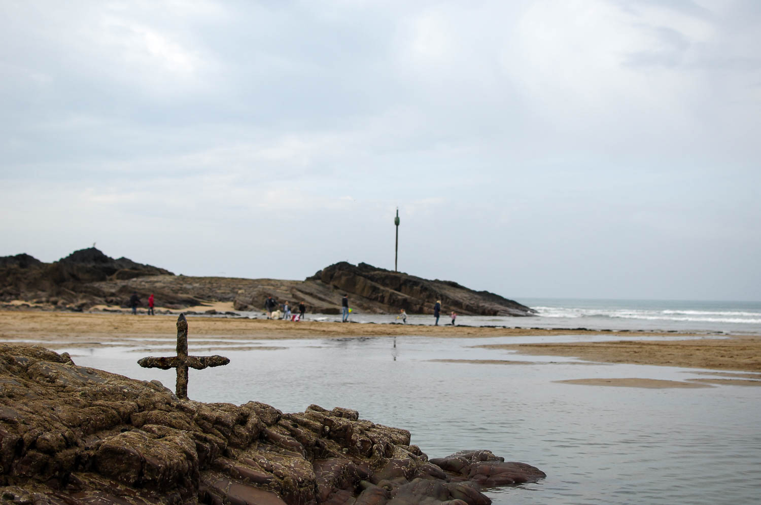
A wonderful compilation to celebrate our connections with the tide – thank you, Natasha
Pingback: Tidal Cultures: An Introduction
Pingback: Sea biscuits – lumps of clay that are ‘hand rolled’ into ovate shapes by the tide | Tidal Cultures
Pingback: Treece – a mark left on intertidal ground by bits of wood and other objects, as they are dragged, and then left stranded, by the last ebbings of a falling tide. | Tidal Cultures
Pingback: A (Poetic) Tidal Glossary – A blog about the environmental (ecological) arts & humanities
Pingback: A few new entries have been added to our (poetic) tidal glossary. | Tidal Cultures
Pingback: “Dutch Fair”, a kind of tidal market held at Great Yarmouth and maybe elsewhere added to our (Poetic) Tidal Glossary. “Dutch pipes, dried flounders, wooden shoes, apples, and gingerbread, are then offered for sale.” | Tidal Culture
Pingback: New entries added to pages; A (poetic) tidal glossary; Tide Related Art Works; and Non-Fiction Books about Tides | Tidal Cultures
Pingback: About this blog and how to use it. | Tidal Cultures
love this!
thank you!
Pingback: New words added to my Tidal Glossary: Maretazo and Syzyigian. | Tidal Cultures
Thank you for this blog post, I enjoyed it immensely. Many beautiful and lyrical words and phrases that would otherwise be lost to the mists of time.
Thanks!
Pingback: A number of new terms have been added to the Tidal Glossary recently | Tidal Cultures